- Daily & Weekly newsletters
- Buy & download The Bulletin
- Comment on our articles
Related articles
Recent

Leisure


Working
Apr 5, 2024

Living
Mar 28, 2024

Belgium
Popular

Living
Sat, 05/27/2023 - 15:26
Living
Wed, 01/03/2024 - 10:25

Living
Fri, 10/27/2023 - 08:57

Belgium
Fri, 01/05/2024 - 18:51

Transport
Tue, 11/14/2023 - 21:46
New website provides geographical data on Belgium
Belgium
13:37 29/11/2013
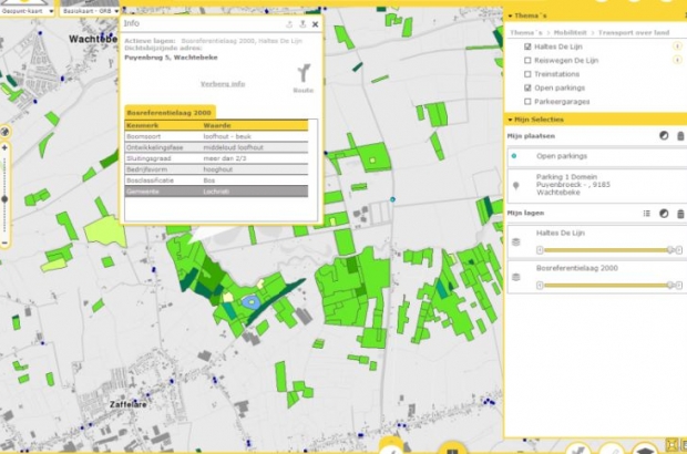
Citizens, companies and government departments now have easy access to all available geographical data on Flanders and Brussels via the portal site Geopunt.be. The online application was presented yesterday during a meeting of the Flemish Geographical Information Agency in Ghent.
On the site, you can find aerial photos of the past 20 years, for instance, and topographical maps from the 18th century. With the info, experts could, say, analyse the historical evolution of soil use or interested citizens could check how their own plots looked in the past. In the course of next year, more data and apps will be added. By May of next year, Geopunt will include information on road works, making it possible to avoid them on your route.