- Daily & Weekly newsletters
- Buy & download The Bulletin
- Comment on our articles
Online map reveals how much heat Brussels buildings waste
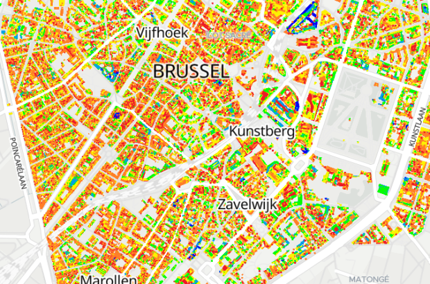
A colour-coded map from the City of Brussels shows the heat loss of various buildings and sites in the Belgian capital.
Using data collected in a flyover done on the 18 January last year, the city has created a record of heat loss from the roofs of all buildings.
Dark blue spots on the map indicate a cold roof, corresponding to a very well-insulated or unoccupied building. In contrast, the red colour indicates a hot roof, meaning significant energy loss.
The thermography is the result of an initiative by the City of Brussels and was carried out by the ACTION AIR study bureau, which used aerial thermography to gather information about the radiation from a surface, meaning the photons that escape.
But there are some caveats to consider when viewing the map. One is that the higher the density of materials, the better their thermal inertia.
This tends to mean that in older houses - usually with small rooms and thick walls - heat exchange is lower, so the roof appears less wasteful. Glass, on the other hand, is much more prone to heat loss.
Materials such as wood or tar absorb a lot of energy during the day, so even a well-insulated roof might not appear blue on the map because the materials it is made of give off energy.
The presence of water, for example if there are visible puddles on a flat roof, can have the same effect on surface radiation.
“We must also take into account the phenomenon of reflection or transmission, which is the angle at which the sun shines on glass or flat surfaces, which can appear warmer because they store heat during the day,” the city’s website explains.
"So if a roof consists of or is surrounded by many glass elements, this can give a higher radiation index (the area appears in red) because the pane or windows store heat well. Very smooth surfaces with high surface reflection can have the same effect (aluminium roofs, for example).
"So watch out for various elements that may prevent your roof data from being interpreted as poorly or well insulated: green roof, trees hanging over the roof, wooden terrace, gravel, solar panels, water, ice, roof and porch windows…"
Brussels residents can check the heat loss in their home or place of work by searching their address or simply exploring the map, but are advised to bear in mind the various factors that could be contributing to a potentially inaccurate reading.
“Our brand new administrative centre looked like an energy sieve at first glance,” Benoît Hellings (Ecolo), alderman for climate, told Bruzz.
"But there is an explanation: the wooden terraces absorb sunlight and release that heat. So it is not heat loss from the building, which we hardly need to heat.
"Conversely, buildings with a good score may not have been heated at the time of recording. Then it only looks like they are well insulated."
Hellings said the research, which cost the city €22,190, was conducted primarily to see how municipal buildings scored.
“We have an exemplary role and are therefore renovating in abundance,” said Hellings.
“The images show where we are doing well and where less so. For example, the swimming pools in Neder-Over-Heembeek and Laeken hardly suffer any heat loss, even though the water there is heated to 26°C.
"So the insulation work there has paid off. An old building such as the Henriette Dachsbeek School in the Marolles, on the other hand, scores poorly."
The hope is that releasing the map of the whole city to the public will encourage property owners to tackle potential heat loss.
Information sessions will also be organised at various locations around the city in the spring in order to address questions.


