- Daily & Weekly newsletters
- Buy & download The Bulletin
- Comment on our articles
Related articles
Recent

Popular


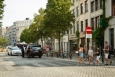

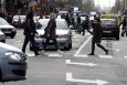
Drone over Sainctelette records invaluable information on traffic flow

The Brussels region has employed a drone for the first time to assess a specific traffic situation. The drone is flying above Sainctelette in the canal district every morning to sketch a traffic pattern of the busy intersection.
There are plans to resurface the Sainctelette area, so authorities would like to know how many cars, trucks, cyclists, pedestrians and trams pass through during rush hour. This will help determine if and what kind of changes are required to traffic infrastructure.
The drone is in the air for two hours during the morning rush hour, some 75 metres above ground. “Normally, we have people in place, as well as cameras, to record traffic situations,” said a spokesperson from the mobility department, “but a drone can do this much more quickly from its aerial vantage point.”
Video obtained by the drone can be used by planning agencies to see how many of each kinds of road user is passing through, “ but also where and how fast they accelerate and decelerate, change lanes and from which directions they come from and go to,” drone expert Philip De Visscher told Bruzz. “They can also see where users come to a standstill and where the danger spots are for pedestrians and cyclists.”
Antwerp and Leuven have both used drones to assess busy traffic intersections. Once this first test phase in Brussels is finished, the region could to use drones to analyse other intersections with heavy traffic.
Photo courtesy Kanal Centre Pompidou


Comments
yeah....video from the drone will be analyzed by the 1258 different governments of belgium